Quantcast
Channel: PCI Geomatics - Latest News
Viewing all 65 articles
Browse latest View live

2013 PCI Reseller Meeting - Summary

$
0
0
2013 PCI Reseller Meeting Summary
"Leveraging the Geomatica Platform"

September 27th, 2013

As the week winds to a close, I thought I would take a few moments and provide a summary of a very exciting week for PCI Geomatics - the 2013 Annual Reseller Meeting was held here in Ottawa from September 23rd to 26th at the Lord Elgin Hotel.


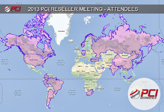
2013 PCI Reseller Meeting - Countries represented in the meeting
PCI was pleased to have the opportunity to host its International Resellers and Partners over the past week for a very fruitful meeting which included a full three-day program of presentations, discussions and training centred on PCI Technology.

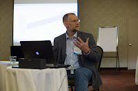
Our first day started with an opening address by PCI Geomatics President and CEO, Terry Moloney who welcomed our international guests and outlined the vision for PCI Geomatics over the coming years. 


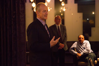
PCI's President and CEO, Terry Moloney
addressing 2013 Reseller Meeting Attendees
A key theme included PCI's continued technological innovations that has fueled customer success, including performance (GPU), flexibility (Cloud implementations) and functionality (new innovative DEM editing tools). Additional presentations from Mr. Moloney as well as Mr. Arnold Hougham, Vice President of Sales and Marketing, positioned Geomatica as a powerful platform that has been leveraged by customers and partners around the world to address complex geospatial challenges. Mr. Moloney and Mr. Hougham presented on the future trends in the geospatial industry and how PCI Geomatics is poised to respond by providing its flexible and powerful Geomatica platform to develop innovative software solutions in response to customer requirements. 

Presentations were provided by PCI's Product Management team on new items for Geomatica, including true ortho and the added availability of 2.5D DEM Editing, which are already available within GXL. Presentations were also provided by key partners including IAVO, Rolta, Digital Globe, the Satrec Initiative and Forest Sense - who presented case studies on how their respective companies use the Geomatica platform on a daily basis. In addition, presentations on upcoming earth observation technology that will be deployed in the short, medium and longer term were presented.


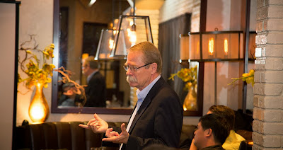
Geoff Zeiss, keynote speaker, "Between the Poles"
The day concluded with a fantastic evening at a local eatery in downtown Ottawa. Digital Globe graciously sponsored the evening dinner which included a keynote address by a geospatial thought leader, Mr. Geoff Zeiss from Between the Poles. His address was enthusiastically received by the audience who learned about the growing need for "real time big data processing", and how PCI and its partners are well positioned to answer to growing customer needs for innovative solutions to upcoming big data challenges. 

The second day of the Reseller meeting featured additional presentations by PCI staff on GXL technology, a high-volume image processing system powered by the Geomatica platform. One of the most exciting presentations was that of Beijing Space Eye Innovations (BSEI) President and CEO, Mr. Xiaoyang Cheng, who summarized short, medium and long term Chinese goals for Earth Observation - which include plans to launch over 20 new earth observation satellites in the coming years. 


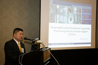
BSEI President and CEO, Mr. Xioayang Cheng, 
presenting at the 2013 PCI Reseller Meeting
BSEI, as PCI's exclusive Reseller in China looks forward to providing innovative solutions to process high volumes of imagery for customers by offering the GXL capability to the Chinese market. In addition to BSEI, Christopher Patterson from Esri Canada provided a case study on Esri's use of the Geomatica platform to map over 50 million square kilometers of 1 m imagery through the use of the GXL, which was deployed on the Amazon Cloud. Mr. Patterson discussed the wealth of imagery and other types of geospatial content available on ArcGIS.com.


Ms. Minnyo Hong, Satrec Initiative
Dinner Sponsor
Additional presentations were provided, including a presentation by PCI SAR expert, Ms. Sandra Bolanos, who provided an overview of the capability within the Geomatica Platform to work with SAR imagery. Key innovations and additions for upcoming compact polarimetry satellite missions were presented along with many application examples using Geomatica and SAR imagery. A second dinner was held at the end of the second day, which was sponsored by the Satrec Initiative.

The dinner also provided an opportunity to recognize the excellent efforts made by PCI's Resellers - in recognition of their contributions to PCI technology and to celebrate their success. The following Resellers received awards:
BSEI (China) , CGI (Germany), Jurupro (Malaysia) and Rolta (India).

2013 PCI Reseller Award Recipients

The third day of the PCI Reseller Meeting included more in-depth training and discussion on PCI Technology, including Geomatica, Synthetic Aperture Radar, Historical Airphoto Processing, and 3D FeatureXtract. One of the main highlights on the final day of the meeting was a presentation by Mr. Nils Erik Jorgensen from Terranor, who presented a very innovative project where underwater imagery was automatically corrected and mosaicked into a continuous data layer using Geomatica.
The solution included taking raw imagery from an Underwater Unmanned Vehicle (UUV) and processing it within the Geomatica platform to automatically correct and color balance the imagery. This innovative technique promises to offer other companies who capture underwater imagery of their infrastructure a solution that allows them to visually inspect and detect problem areas underwater, without the expense and risk associated with sending highly trained underwater divers.


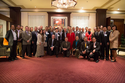
2013 PCI Reseller Meeting - Group Photo

If you are interested in joining our growing network of International Resellers, or would like to partner with us, please contact us to discuss the benefits of working with PCI Geomatics.
Email us at marketing@pcigeomatics.com or head to www.pcigeomatics.com.

In closing, we would like to thank all PCI resellers, partners, and all of the PCI Staff who supported the 2013 Annual Reseller Meeting, which was indeed very successful.

To view a complete Picture Gallery captured throughout the week, click on this link:
2013 PCI Reseller Meeting Picture Gallery

Kevin Jones
Director, Marketing and Communications
jones@pcigeomatics.com


PCI Geomatics and Sysdeco Italia Announce Geomatica Day at the University of Rome

$
0
0
RICHMOND HILL, Ontario, Canada—October 8, 2013: PCI Geomatics, a world leading developer of geo-imaging software and systems, today announces that, along with its Italian reseller, Sysdeco Italia, it will be holding Geomatica Day on the 14th of October, 2013 at the historic Faculty of Engineering at the Sapienza University of Rome in Rome, Italy.

The one-day event will cover a range of topics relating to geospatial imagery and the use of Geomatica software. Participants will be shown the latest tools in Geomatica 2013, image processing examples using Pleiades data, and real-world case studies on how Geomatica software and solutions are being used by customers around the world.

“We are honored to be presenting at such a historic place in the world,” said Steven Corr, European Business Manager at PCI Geomatics. “I am personally looking forward to what promises to be a day filled with informative and insightful discussions about geospatial imagery.”

In addition to Geomatica, demonstrations of new products including Discover and 3D FeatureXtract will be provided. Hands-on training sessions focusing on atmospheric correction, haze removal, and change detection will be included, providing practical examples of image processing workflows. Event participants will also receive 30-day trial licenses of the latest release of Geomatica.

Space for this event is limited. Interested parties can register by contacting sales@sysdecoitalia.com.

About PCI Geomatics
PCI Geomatics is a world-leading developer of software and systems for remote sensing, imagery processing, and photogrammetry.  With more than 30 years of experience in the geospatial industry, PCI is recognized globally for its excellence in providing software for accurately and rapidly processing satellite and aerial imagery.  There are more than 30,000 PCI licenses, in over 150 countries worldwide. Find out more about PCI Geomatics at www.pcigeomatics.com.

Press Contact
Kevin R. Jones
Director, Marketing and Communications
T: 819-770-0022 x 214
E:
jones@pcigeomatics.com
Web:
www.pcigeomatics.com
Twitter: @pcigeomatics

PCI Geomatics Delivers Historical Airphoto Processing (HAP) System in Sabah, Malaysia

$
0
0
RICHMOND HILL, Ontario, Canada—November 7, 2013: PCI Geomatics, a world leading developer of geo-imaging software and systems, today announces that it has successfully delivered to the Sabah Lands and Surveys Department (SLSD) a Historical Airphoto Processing (HAP) system, a customized workflow developed by PCI Geomatics. Installation and training, which took place in September of this year, were included in the delivery of the system.

Sabah, one of 13 member states which comprise Malaysia, is located on the northern portion of the island of Borneo, and has a total land area of 73,631 km2. The Sabah Lands and Surveys Department has secured the use of a HAP system within its organization in order to produce seamless ortho mosaics for the over 40,000 historical images it possesses in its archive – dating from the 1970’s, 1980’s, 1990’s and 2000’s.

The Sabah Lands and Surveys Department received onsite training from PCI’s HAP experts who travelled to Kota Kinabalu, the capital of Sabah, in order to install and provide training. Using an iterative approach and leveraging automated Ground Control Point collection techniques, large blocks of images from the archives were successfully orthorectified, and mosaicked.

Previously, historical images were made available to the public through the SLSD central office location in Kota Kinabalu, however this only provided limited use of the imagery. By proactively correcting all of the imagery from the various years, the SLSD will be significantly increasing transparency for key issues that deal with land ownership, natural resources, and change detection dating back to the 1970’s.

“Prior to implementing the Historical Airphoto Processing System, the distribution of imagery was limited to onsite consultation in our offices,” said Robert Cheng, Assistant Director of Survey & Mapping. “The HAP system will allow us to produce highly accurate, color-balanced orthorectified digital mosaics that can be consulted through our Sabah Land Information System (SALIS), through the Internet.”

“We are pleased to see that this valuable source of imagery will be preserved and will continue to provide value to its owners, and to the citizens of Sabah,” said Wong Tai Hong, General Manager at, Jurupro SND BHD, PCI’s Reseller in Malaysia. “The customer was impressed with the HAP system’s capability and immediately identified a need to use the system to process imagery in their archive in order to preserve its value,” he added.

PCI Geomatics recently introduced the Historical Airphoto Processing Workflow, which leverages the Geomatica platform to produce ortho-mosaics from difficult-to-process scanned historical imagery. The system is successfully being used in Canada, the US, Europe, the Middle East and Asia.

About PCI Geomatics
PCI Geomatics is a world-leading developer of software and systems for remote sensing, imagery processing, and photogrammetry.  With more than 30 years of experience in the geospatial industry, PCI is recognized globally for its excellence in providing software for accurately and rapidly processing satellite and aerial imagery.  There are more than 30,000PCI licenses, in over 150 countries worldwide. Find out more about PCI Geomatics at www.pcigeomatics.com.

Press Contact
Kevin R. Jones
Director, Marketing and Communications
T: 819-770-0022 x 214
E:
jones@pcigeomatics.com
Web:
www.pcigeomatics.com

Twitter: @pcigeomatics

Canadian Government Matching Donations to Typhoon Haiyan Relief Organizations

$
0
0
Typhoon Haiyan – locally known as Yolanda –is the strongest typhoon to hit the Philippines in 2013. The storm has caused widespread damage, including landslides and flooding. Among the people affected are those who were left homeless by an earthquake in mid-October

The Canadian government has set up the Philippines crisis fund to address the needs of affected populations in the Philippines, and will match individual donations from Canadians to registered charities.

Canadians wishing to help individuals affected by this storm are encouraged to make a financial donation online, at their local Red Cross office, or by calling 1-800-418-1111. Please earmark donations “Typhoon Haiyan.” Funds will be used to support Red Cross efforts in all countries affected by the storm.

To make a donation directly to the Canadian Red Cross to support efforts towards Typhoon Haiyan Relief, visit: http://www.redcross.ca/donate/donate-online/donate-to-the-typhoon-haiyan-fund.

To learn more about The Canadian Government's Response to Typhoon Haiyan, visit: http://www.acdi-cida.gc.ca/acdi-cida/acdi-cida.nsf/eng/HEL-111012596-P4H

PCI Geomatics, Feng Chia University and Lotus (H&R) Inc. Sign International Industry-Academia Cooperation Agreement

$
0
0
RICHMOND HILL, Ontario, Canada—November 13, 2013: PCI Geomatics, a world-leading developer of geoimaging software and systems, announced today that it has signed an Industry-Academia Cooperation Agreement with Feng Chia University (FCU), located in Taichung, Taiwan, and Lotus (H&R) Inc., exclusive reseller of PCI Geomatics technology in Taiwan.

In order to promote cooperation and knowledge exchange, PCI Geomatics has created the “PCI Geomatics Education Alliance Program” designed to create strong reciprocal relationships with select educational institutions. Under the terms of the Alliance Program, PCI Geomatics provides software licenses to support teaching and research activities in exchange for insights into the work being conducted at the University with PCI Geomatics software. The program fosters communication between the University and PCI Scientists as well as provides an outlet to the commercial world highlighting the work conducted at the University using PCI Geomatics software.

PCI Geomatics will be supporting the University through its exclusive distributor to Taiwan, Lotus (H&R) Inc. Lotus will deliver software support services for PCI software via onsite visits and through regular communications, as well as provide assistance with localized training and documentation material in Mandarin.

“PCI is pleased to sign this important agreement in person here in Taichung, as we greatly value the contributions of universities and other educational institutions to advance our collective knowledge of remote sensing science and applications,” said Terance M. Moloney, President and CEO of PCI Geomatics. “The purpose of the Education Alliance Program is to support the education sector, which acts as a beacon for teaching, research and innovation.”

“We are pleased to have been selected to participate in PCI’s Education Alliance Program,” said Dr. Lung-Shih Yang, Vice President of Feng Chia University. “Geomatica is an excellent teaching aid in conveying the fundamentals of Remote Sensing and Digital Image Processing. In addition, it offers excellent tools for customization that are leveraged for research in directed studies.”

PCI Geomatics has implemented other Educational Alliance Agreements recently, and aims to have regional representation throughout the world. Follow the links below to access photos and a video of the signing ceremony.

Pictures of signing ceremony are available at: pci.gl/HRmpLc
Video of the signing ceremony is available at: pci.gl/17pKSO1
(Photos and Video – Copyright © 2013 FCU)

About PCI Geomatics
PCI Geomatics is a world-leading developer of software and systems for remote sensing, imagery processing, and photogrammetry.  With more than 30 years of experience in the geospatial industry, PCI is recognized globally for its excellence in providing software for accurately and rapidly processing satellite and aerial imagery.  There are more than 30,000 PCI licenses, in over 150 countries worldwide. Find out more about PCI Geomatics at www.pcigeomatics.com.

About Feng Chia University
Feng Chia University, located in Taichung, Taiwan, was initially established in 1961 as a College of Engineering and Business, and was granted University status in 1980. For over 50 years, FCU has steadily increased in size and scope. Currently, it is comprised of eight schools and colleges. Find out more about Feng Chia University at http://en.fcu.edu.tw/.

About Lotus (H&R) Inc.
Lotus (H&R) is a leading high-resolution optical and SAR satellite image distributor and geospatial
services provider in Taiwan. Lotus has decades of experience in sales of GIS products and services and
extensive business support networks in the marketplace. To contact Lotus (H&R) Inc:

Rubia Chen
T: +886 2 27226147
M : + 886 912596975
E : rubia.chen@gmail.com


Press Contact
Kevin R. Jones
Director, Marketing and Communications
T: 819-770-0022 x 214
E:
jones@pcigeomatics.com
Web:
www.pcigeomatics.com

Twitter: @pcigeomatics

PCI Geomatics Celebrates GIS Day in Ottawa by Awarding Carleton University Student with Academic Achievement Award

$
0
0
RICHMOND HILL, Ontario, Canada—November 21, 2013: PCI Geomatics, a world-leading developer of geoimaging software and systems, announced today that it presented an award to Carleton University student Rachel Plewes in recognition of her academic achievements.

The award was presented at a GIS Day event held at Carleton University at the newly unveiled Discovery Centre, atop the MacOdrum Library (fourth floor). The Discovery Centre is an interactive learning space equipped with state-of-the-art technology and ergonomic seating. GIS Day was the first event held in the new centre, and featured the participation of academia, industry, government and Carleton University students.

PCI Geomatics Director of Marketing, Kevin Jones, presented a lightning talk entitled Enabling Customer Success Through Geospatial Software Innovation, and awarded Rachel Plewes the PCI Geomatics Award for top student at Carleton University in the field of Geomatics for 2012-2013. Also on hand to present the award was Adjunct Professor Dr. Andrew Davidson, who teaches Remote Sensing at the University.

“Rachel is industrious, works independently, and has demonstrated excellent command of the course material – attaining an A+ grade in my course”, said Dr. Davidson. “Rachel is currently completing her MSc research thesis, and has used Geomatica extensively throughout the course and in the lab exercises.”

PCI Geomatics is a longtime supporter of the academic sector, providing software and assistance to Universities around the world, helping students to learn the fundamentals of Remote Sensing and Photogrammetry. PCI recognizes the importance of supporting students who are learning and conducting important research in the field of Geomatics, and has presented other similar student achievement awards in the past.

To view pictures from the GIS Day Event /award, please click on this link:

About PCI Geomatics
PCI Geomatics is a world-leading developer of software and systems for remote sensing, imagery processing, and photogrammetry.  With more than 30 years of experience in the geospatial industry, PCI is recognized globally for its excellence in providing software for accurately and rapidly processing satellite and aerial imagery.  There are more than 30,000 PCI licenses, in over 150 countries worldwide. Find out more about PCI Geomatics at www.pcigeomatics.com.

Press Contact
Kevin R. Jones
Director, Marketing and Communications
T: 819-770-0022 x 214
E:
jones@pcigeomatics.com
Web:
www.pcigeomatics.com

Twitter: @pcigeomatics

PCI Geomatics Presents Rolta with the Dr. Robert Moses Memorial Award for Entrepreneurial Spirit and Product Innovation

$
0
0
RICHMOND HILL, Ontario, Canada—November 25, 2013: PCI Geomatics, announced today that it has presented Rolta with the Dr. Robert Moses Memorial Award for Entrepreneurial Spirit and Product Innovation. Dr. Robert Moses (“Dr. Bob”), past President and CEO of PCI Geomatics, was an exceptional leader and visionary who left behind a legacy of excellence in remote sensing and geospatial technology.  In memory of Dr. Bob, the award was formed to honor the organization that best exemplifies a model for others to follow in actively pursuing the development and adoption of geospatial technology while making a positive impact on the environment and society.

For over 30 years Rolta has been dedicated to bringing innovative remote sensing and geospatial solutions to customers in India and around the globe.  This award is a testament to Rolta’s accomplishments in business growth, innovation in product development and service offerings for sophisticated remote sensing applications. 
“We value Rolta as a long term Strategic Partner and appreciate their initiative to develop new and innovative geospatial applications and workflows for the many global customers who require operational solutions,” said Terry Moloney, President and CEO, PCI Geomatics.

Mr. K. K. Singh, Chairman and Managing Director of Rolta commented, “Rolta has a unique business model based on a combination of specialized knowledge in the domains of Information Technology, Geospatial, Engineering, Defense and Security, which coupled with our own intellectual property, enables Rolta to provide high value solutions to the critical needs of our customers.  We appreciate the recognition of Rolta’s success, and honor Dr. Bob for his leadership and entrepreneurial spirit.”

About PCI Geomatics
PCI Geomatics is a world-leading developer of software and systems for remote sensing, imagery processing, and photogrammetry.  With more than 30 years of experience in the geospatial industry, PCI is recognized globally for its excellence in providing software for accurately and rapidly processing satellite and aerial imagery.  There are more than 30,000 PCI licenses, in over 150 countries worldwide. Find out more about PCI Geomatics at www.pcigeomatics.com.

About Rolta:
Rolta is a leading provider of innovative IT solutions for many vertical segments, including Federal and State Governments, Defense/HLS, Utilities, Process, Power, Financial Services, Manufacturing, Retail, and Healthcare. By uniquely combining its expertise in the IT, Engineering and Geospatial domains, Rolta develops exceptional solutions for these segments. The Company leverages its industry-specific know-how, rich repository of intellectual property that spans photogrammetry, image processing, geospatial applications, business intelligence, analytics, field-proven solution frameworks, and deep expertise in cutting-edge technologies like Geo BI, Cloud computing, Software Defined Infrastructure and Big Data for providing sophisticated enterprise-level integrated solutions. Rolta is a multinational organization headquartered in India. The Company operates from 40 locations worldwide through its subsidiaries, and has executed projects in over 45 countries. The Company benchmarks its quality processes to the world’s best standards, like successful assessment for Software Application Development and Maintenance at the highest Level 5 of SEI's CMMI® version 1.3. Rolta is listed on the Bombay Stock Exchange & National Stock Exchange, and forms part of various indices on BSE/NSE in India. The Company's GDRs are listed on the Main Board of London Stock Exchange. The Company’s ‘Senior Notes’ are listed on Singapore Stock Exchange.

For additional information: visit www.rolta.com, or contact:
Atul Tayal
Jt. MD & COO – Domestic Operations
Member of the Board
adtayal@rolta.com
Telephone: +91 (22) 2926 6666
Preetha Pulusani
President, International (Americas
Member of the Board
Telephone: +1 (678) 942 5000
Rajesh Ramachandran
President & CTO
Global Products & Technology Solutions
Rajesh.Ramachandran @rolta.com
Telephone: +91 (22) 2926 6666

Disclaimer: This press release includes statements that are not historical in nature and that may be characterized as "forward-looking statements", including those related to future financial and operating results, benefits and synergies of the Company's brands and strategies, future opportunities and the growth of the market for open source solutions. You should be aware that Rolta's actual results could differ materially from those contained in the forward-looking statements, which are based on current expectations of Rolta management and are subject to a number of risks and uncertainties, including, but not limited to, Rolta's ability to integrate acquired operations and employees, Rolta's success in executing its strategies, Rolta's ability to take a competitive position in the industry, business conditions and the general economy, market opportunities, potential new business strategies, competitive factors, sales and marketing execution, shifts in technologies or market demand, and any other factors. We may make additional written and oral forward-looking statements but do not undertake, and disclaim any obligation, to update them.

Press Contact
Kevin R. Jones
Director, Marketing and Communications
T: 819-770-0022 x 214
E: 
jones@pcigeomatics.com
Web: 
www.pcigeomatics.com

Twitter: @pcigeomatics

PCI Geomatics Releases Service Pack 3 for Geomatica 2013

$
0
0
RICHMOND HILL, Ontario, Canada—December 11, 2013: PCI Geomatics, a world leading developer of remote sensing and photogrammetric software and systems, announces it has released its Geomatica 2013 Service Pack 3 (SP3).

This release contains maintenance fixes and includes all updates delivered since Service Pack 2 was released for Geomatica 2013. The update is available for both Windows and Linux-based operating systems.

In addition, Geomatica 2013 SP3 continues its tradition of industry-leading sensor support by including support for Göktürk-2 and the recently launched SkySat-1, as well as improved support for several sensors such as SPOT-6, UAVSAR, Landsat 1-5, RapidEye, and TH-01. The Service Pack also includes additional support for Landsat-8, mainly the ability to apply Atmospheric Correction algorithms to the imagery.

It is recommended that customers using Geomatica 2013 download and install this service pack at their earliest convenience to ensure the highest-quality experience when working with the software. The service pack can be accessed by visiting the updates page at www.pcigeomatics.com/support/updates.

Customers who have any questions or run into issues with the installation should contact PCI’s Support team at support@pcigeomatics.com, or visit the support site at www.pcigeomatics.com/support.

About PCI Geomatics
PCI Geomatics is a world-leading developer of software and systems for remote sensing, imagery processing, and photogrammetry.  With more than 30 years of experience in the geospatial industry, PCI is recognized globally for its excellence in providing software for accurately and rapidly processing both satellite and aerial imagery.  PCI has installed more than 30,000 licenses, in over 150 countries worldwide. Find out more about PCI Geomatics at www.pcigeomatics.com.

Press Contact
Kevin R. Jones
Director, Marketing and Communications
T: 819-770-0022 x 214
E:
jones@pcigeomatics.com
Web:
www.pcigeomatics.com

Twitter: @pcigeomatics

PCI Geomatics Awards Beijing Space Eye Innovation (BSEI) as the #1 Platinum Reseller

$
0
0
RICHMOND HILL, Ontario, Canada—December 16, 2013: PCI Geomatics, a world leading developer of remote sensing and photogrammetric software and systems, announced today that it has awarded Beijing Space Eye Innovation Technology Co. Ltd (BSEI) as the company’s  #1 Platinum Reseller for 2013. The award recognizes BSEI as the top reseller within the PCI Geomatics Reseller Network.

In 2009, PCI Geomatics appointed BSEI as the Exclusive Reseller for Geomatica in China to better serve the needs of the local customers; where the geospatial sector has seen significant growth over the last decade. In January of this year, the Exclusive Reseller Agreement was expanded to include other leading edge technology developed by PCI Geomatics, most notably the GeoImaging Accelerator (GXL) which was developed in response to the need for handling extremely large processing projects.

The demand in China for operational tools that rapidly provide accurate image maps has increased greatly given the investment the Chinese Government is making in the geospatial sector. Collection frequency and the sheer volume of geospatial data has consistently been on the rise as new satellite sensors are developed and launched; increasing the collection capacity and variety of imagery that is collected. Over the last several years, BSEI has been a very active reseller for PCI Geomatics, investing and developing its internal staff to work with, and support, the local customers.

“We feel it is important to provide localized versions of the software, as well as technical documentation such as white papers, to ensure customers in China can properly appreciate and evaluate the powerful technology developed by PCI Geomatics,” said Xiaoyang Cheng, President,BSEI. “In China, there are currently plans to launch many new earth-observing constellations, each containing several satellites over the next few years. The demand for operational solutions to work with these large volumes of imagery will be considerable. PCI’s large volume processing technology is a perfect fit for these Big Data challenges.”

“We are very pleased to honour and recognize the work of BSEI in representing PCI Geomatics in China,” said Terry Moloney. President and CEO of PCI Geomatics. “The energy and efforts that are being invested in China’s geospatial sector are quite remarkable. PCI Geomatics, together with BSEI is providing customers in China with innovative technology to address these Big Data challenges.”

About PCI Geomatics
PCI Geomatics is a world-leading developer of software and systems for remote sensing, imagery processing, and photogrammetry.  With more than 30 years of experience in the geospatial industry, PCI is recognized globally for its excellence in providing software for accurately and rapidly processing both satellite and aerial imagery.  PCI has installed more than 30 thousand licenses, in over 150 countries worldwide. Find out more about PCI Geomatics at www.pcigeomatics.com.


About BSEI
Beijing Space Eye Innovation Technology Co. Ltd. (BSEI) has many years of experience of distributing satellite imagery and world leading image processing software in the Chinese market. BSEI is also the global channel partner of Chinese imaging satellite, TH-1. BSEI provides professional image processing services, information systems integration and related technical training. Based in Beijing China, BSEI has more than 80% of their staff with specialized, advanced degrees in the fields of Remote Sensing and GIS. Since 2005, BSEI has provided more than 2,000 users in China and abroad with various satellite imagery, software as well as data processing services and training. Find out more at: www.bsei.com.cn

Press Contact
Kevin R. Jones
Director, Marketing and Communications
T: 819-770-0022 x 214
E:
jones@pcigeomatics.com
Web:
www.pcigeomatics.com
Twitter: @pcigeomatics

PCI Geomatics Updates Historical Airphoto Processing Workflow

$
0
0
RICHMOND HILL, Ontario, Canada—January 22, 2014: PCI Geomatics, a world leading developer of remote sensing and photogrammetric software and systems, announced today that it has updated its Historical Airphoto Processing (HAP) workflow.

The HAP workflow, released to the public in March of 2013, provides a semi-automated means to align, orthorectify, and mosaic digitally scanned airphotos. The system can greatly reduce manual labor, increase throughput, and achieve high accuracy. This update adds a functional and intuitive Graphical User Interface (GUI) to the workflow.

“The strong demand for historical airphoto processing drove the decision to add a user-friendly interface to the HAP system,” said David Piekny, Product Marketing Manager at PCI Geomatics. “The GUI further simplifies the process, allowing more users to take advantage of this technology and unlock their historical archives.”

The HAP workflow uses multi-pass processing and automated ground control and tie point collection.  This produces an accurate math model that can be used to generate individual orthos or seamless ortho-mosaics from hundreds or thousands of airphotos without camera calibration files. The system is built with PCI’s proven Geomatica technology and can be scaled to meet all requirements for historical airphoto correction.

The HAP workflow corrects imagery to make it usable in GIS and image processing software environments so users can benefit from multi-year image analysis, tracking changes that have occurred across the landscape.

“For decades, access to historical imagery was typically restricted to archives and difficult to access – requiring onsite consultations that consume valuable time and resources,” explained Piekny. “Even in cases where the photos were scanned and cataloged digitally, use in GIS applications was severely limited due to misalignment and scale. HAP changes that, and the update makes it even easier to modernize a complete collection.”

For more information about PCI’s Historical Airphoto Processing workflow, visit: www.pcigeomatics.com/HAP.

Downloadable images of the GUI suitable for publication can be accessed at: www.pcigeomatics.com/pressnews/photos/PCI-HAP-GUI.jpg.

About PCI Geomatics
PCI Geomatics is a world-leading developer of software and systems for remote sensing, imagery processing, and photogrammetry.  With more than 30 years of experience in the geospatial industry, PCI is recognized globally for its excellence in providing software for accurately and rapidly processing both satellite and aerial imagery.  PCI has installed more than 30 thousand licenses, in over 150 countries worldwide. Find out more about PCI Geomatics at www.pcigeomatics.com.


Press Contact
Kevin R. Jones
Director, Marketing and Communications
T: 819-770-0022 x 214
E:
jones@pcigeomatics.com
Web:
www.pcigeomatics.com

Twitter: @pcigeomatics

PCI Geomatics Delivers GXL Satellite Image Processing System to Instituto Geográfico Agustín Codazzi (IGAC)

$
0
0
Versión en español abajo

RICHMOND HILL, Ontario, Canada—January 28, 2014: PCI Geomatics, a world leading developer of remote sensing and photogrammetric software and systems, announced today that, through its Colombian reseller, GeoSpatial Engineering, it has delivered a GeoImaging Accelerator (GXL) Satellite and Aerial processing system to the Instituto Geográfico Agustín Codazzi (IGAC).

IGAC is the entity responsible for producing the official map and the basic cartography of Colombia; developing the national property register; creating the soil characteristics inventory; advancing geographic investigations in support of territorial development; training and educating professionals in geographic information technologies, and coordinating the “Colombian Spatial Data Infrastructure” or ICDE. IGAC will be using the GXL image processing system to produce accurately orthorectified basemaps for all of Colombia.

“The speed, accuracy, and multi-sensor support of the system were determining factors in selecting PCI’s GXL for our projects,” said Jaime Duarte, Assistant Director of Cartography and Mapping at IGAC. “Creating mosaics of over 1,000,000 km2 is an enormous task that requires the exceptional speed and automation that, we found, only GXL can provide.”

PCI’s exclusive reseller in Colombia, GeoSpatial, specializes in information solutions, development and technology infrastructure. A PCI reseller for 15 years, the company has a highly qualified team of specialists in Geomatics and infrastructure engineers focusing its efforts on engineering solutions for public and private organizations that include information management, 3D technologies and the latest geospatial methods for deriving valuable information for decision making.

“GeoSpatial prides itself in delivering custom tailored geo-imaging and GIS solutions to organizations of all sizes,” said Carlos Niño, General Manager at GeoSpatial. “I am pleased that the team here was able to identify the GXL as a solution suitable for IGAC’s projects.”

“IGAC is a demanding customer and a national and regional leader in the production and dissemination of geospatial information, so we are pleased to have won this important contract with our GXL-Satellite and GXL-Aerial systems and offer leading edge technology to IGAC,” said Arnold Hougham, VP – Sales and Marketing at PCI Geomatics. “GeoSpatial and the delivery team here at PCI did an excellent job in helping IGAC recognize the value of high speed, multi-sensor image processing as it relates automating time consuming tasks. GXL will provide the organization with the ability to generate their geo-image products in a fast, efficient manner."

About PCI Geomatics
PCI Geomatics is a world-leading developer of software and systems for remote sensing, imagery processing, and photogrammetry.  With more than 30 years of experience in the geospatial industry, PCI is recognized globally for its excellence in providing software for accurately and rapidly processing both satellite and aerial imagery.  PCI has installed more than 30 thousand licenses, in over 150 countries worldwide. Find out more about PCI Geomatics at www.pcigeomatics.com.

Press Contact
Kevin R. Jones
Director, Marketing and Communications
T: 819-770-0022 x 214
E:
jones@pcigeomatics.com
Web:
www.pcigeomatics.com
Twitter: @pcigeomatics


PCI Geomatics hace entrega del Sistema de Procesamiento de Imágenes Satelitales GXL al Instituto Geográfico Agustín Codazzi - IGAC


RICHMOND HILL, Ontario, Canadá, enero 28, 2014: PCI Geomatics, líder mundial en desarrollo de software y sistemas fotogramétricos y de teledetección, anunció hoy que, a través de su distribuidor en Colombia, GeoSpatial, ha hecho entrega del Acelerador de Orto-Imágenes (GXL), Sistema de Procesamiento satelital y aéreo, al Instituto Geográfico Agustín Codazzi (IGAC).

El Instituto Geográfico Agustín Codazzi, IGAC, es la entidad encargada de producir el mapa oficial y la cartografía básica de Colombia, elaborar el catastro nacional, los estudios de suelos, las investigaciones geográficas como apoyo al desarrollo territorial, capacitar y formar profesionales en tecnologías de información geográfica y coordinar la Infraestructura Colombiana de Datos Espaciales (ICDE). El IGAC utilizará el sistema de procesamiento de imágenes GXL para producir mapas base orto rectificados de alta precisión para toda Colombia.

“La velocidad, la precisión y el soporte multi sensor del sistema fueron los factores determinantes en la selección del software GXL de PCI para nuestros proyectos”, dijo Jaime Duarte, Subdirector de Geografía y Cartografía del IGAC. “Crear mosaicos de cerca de 1.000.000 de km2es una enorme tarea que requiere la velocidad excepcional y la automatización que según vemos, solo GXL puede proporcionar”.

GeoSpatial, distribuidor exclusivo de PCI en Colombia, se especializa en desarrollo de soluciones de información geográfica y tecnología para infraestructura. Como distribuidor de PCI por más de 15 años, la compañía cuenta con un equipo de especialistas en Geomática e ingenieros de infraestructura altamente calificados que enfocan sus esfuerzos en soluciones de ingeniería para organizaciones públicas y privadas, lo que incluye manejo de información  y tecnologías 3D y las últimas novedades geoespaciales para obtener información valiosa para tomar decisiones.

“GeoSpatial se enorgullece de entregar soluciones hechas a la medida  de SIG y de orto-imágenes, a organizaciones de todos los tamaños” dijo Carlos Niño, Gerente General de GeoSpatial. “Me complace que nuestro equipo haya sido capaz de identificar el software GXL como la solución idónea para los proyectos del IGAC”.

“El IGAC es un cliente exigente y un líder nacional y regional en la producción y difusión de información geoespacial, así que nos complace haber ganado este importante contrato con nuestro sistema GXL Satelital y aéreo y poder ofrecer tecnología de punta al IGAC” dijo Arnold Hougham, Vicepresidente de Ventas y Mercadeo en PCI Geomatics. “GeoSpatial y el equipo técnico de PCI, hicieron un excelente trabajo, ayudándole al IGAC a reconocer el valor de la alta velocidad, procesamiento de imágenes multi-sensor en lo que respecta a la automatización del tiempo que consumen las tareas. GXL proveerá a la organización la capacidad de generar sus productos de orto-imágenes de manera rápida y eficiente”.

Acerca de PCI Geomatics
PCI Geomatics es líder mundial en el desarrollo de software y sistemas para teledetección y procesamiento de imágenes y fotogrametría. Con más de 30 años de experiencia en la industria geoespacial, PCI es reconocido globalmente por su excelencia en el suministro de software para procesamiento rápido y preciso de imágenes aéreas y satelitales. PCI ha instalado más de 30 mil licencias en cerca de 150 países alrededor del mundo. Encuentre más acerca de PCI Geomatics en www.pcigeomatics.com.

Contacto de Prensa
Kevin R. Jones
Director de Mercadeo y Comunicaciones
T: 819-770-0022 x 214
E:
jones@pcigeomatics.com
Web:
www.pcigeomatics.com
Twitter: @pcigeomatics

PCI Geomatics and the SATREC Initiative sign Memorandum of Understanding

$
0
0
RICHMOND HILL, Ontario, Canada—February 3, 2014: PCI Geomatics, a world leading developer of remote sensing and photogrammetric software and systems, announced today that is has signed a Memorandum of Understanding with the SatrecInitiative, a leading solution provider for Earth observation missions, based in Daejeon, South Korea.

The agreement is intended to develop commercial relations between the two companies and promote the operational use of KOMPSAT imagery on a global basis, most notably the recently launched KOMPSAT-3 satellite. KOMPSAT-3 is an optical imaging satellite capable of imaging the Earth with a resolution of 0.70 m Panchromatic and 2.8 m Multispectral (Blue, Green, Red, Near-IR). KOMPSAT-3 includes the Advanced Earth Imaging Sensor System (AEISS), which is a high-resolution imager (Pan and MS). The imagery is commercially available through the Satrec Initiative.

Some of the key activities that will be implemented as a result of this agreement are the provision of sample KOMPSAT-3 imagery that can be distributed with Geomatica, PCI’s flagship software platform. In addition, the Satrec Initiative will provide imagery to applications specialists and scientists at PCI Geomatics in order to develop automated and highly accurate methods of correcting large volumes of the imagery, as well as to develop innovative application examples and demonstrations for operational applications.

Together with the Satrec Initiative, PCI Geomatics will host webinars that will showcase possible applications through the use of the imagery and the Geomatica software platform. “We are very pleased to be working with the Satrec Initiative to further develop operational uses KOMPSAT-3imagery,” said Arnold Hougham, Vice President of Sales and Marketing at PCI Geomatics. “There is a great deal of synergy between the Satrec Initiative and our company, most notably with the recent launch of KOMPSAT-5, a Synthetic Aperture Radar (SAR) X-band satellite. Our existing Geomatica Suite is perfectly suited for end users working with KOMPSAT-3 imagery, and with the upcoming release of commercial imagery from KOMPSAT-5, our Geomatica Radar Suite will provide additional capabilities for viewing, and analysis of this new source of imagery.”

We are so excited to be working with PCI Geomatics to introduce alternative earth observation resources from the KOMPSAT constellation to the remote sensing user society,” said Moongyu Kim, Vice President of Satellite Image Services at the Satrec Initiative.“KOMPSAT-2 and KOMPSAT-3 are cost-effective VHR optical satellites and KOMPSAT-5 is a new X-band SAR satellite. We are sure that Geomatica with KOMPSAT imagery will demonstrate the great combination of powerful analysis tools and cost effective imagery sources.”
For more information on KOMPSAT-3 and to learn more about Geomatica, please visit the following websites:


About PCI Geomatics
PCI Geomatics is a world-leading developer of software and systems for remote sensing, imagery processing, and photogrammetry.  With more than 30 years of experience in the geospatial industry, PCI is recognized globally for its excellence in providing software for accurately and rapidly processing both satellite and aerial imagery.  PCI has installed more than 30 thousand licenses, in over 150 countries worldwide. Find out more about PCI Geomatics at www.pcigeomatics.com.

About the SATREC Initiative
Satrec Initiative is the leading solution provider for Earth observation missions, offering customers worldwide high performance, cost-effective turnkey satellite platforms, electro-optical instrument, ground systems and components as well as training and consultancy services. Focusing sincerely on the customers’ needs with innovative technologies, Satrec Initiative has delivered optimized high quality solutions to over 20 customers in the Middle East, Asia and Europe. 

Founded in 1999, the Satrec Initiative is a private company listed in KOSDAQ. The company currently has over 130 employees with corporate headquarter in Daejeon, South Korea. Additional information about the company can be found at www.satreci.com.  

Press Contact
Kevin R. Jones
Director, Marketing and Communications
T: 819-770-0022 x 214
E:
jones@pcigeomatics.com
Web:
www.pcigeomatics.com
Twitter: @pcigeomatics

PCI Geomatics Delivers Historical Airphoto Processing (HAP) System to USDA Forest Service

$
0
0
RICHMOND HILL, Ontario, Canada—February 6, 2014: PCI Geomatics, a world leading developer of geo-imaging software and systems, announced today that it has successfully delivered its high-speed and automated Historical Airphoto Processing (HAP) system to the USDA’s Forest Service office in Region 5 (California and Pacific Islands).

“Having orthorectified historic imagery will allow us to better understand how ecological processes and disturbance patterns have shaped the ecosystems we manage,” said Carlos Ramirez, Team Leader of the Remote Sensing Laboratory at USDA Forest Service’s Region 5. Nathan Amboy, an analyst at the lab, states that “Using HAP, we plan to generate digitally mosaicked datasets from the archived historical imagery that can be used to conduct change detection and analysis. In our archives, we have access to imagery dating back to the 1930’s that can analyzed; the first steps to make this possible include scanning, correcting and orthorectifying the historical imagery to ensure that the information extracted is accurate and can be used for change detection.”

“The HAP system automates what used to be a very manual process, providing typical processing capability on the order to 1,000 to 1,500 orthos per operator, per week,” said Clark Selby, US Regional Solutions Manager for PCI Geomatics. “Our HAP system is increasingly being adopted since it provides a viable method to process historical imagery and bring it into modern day geospatial systems.”

In recent years, the Forest Service has seen an increasing demand for historical imagery from local Forest Service offices, as well as internal and University based forest researchers. Historical imagery is currently stored on hardcopy prints within the Forest Service’s facilities. Local officials and researchers are limited to accessing and analyzing historical information on the physical prints, which greatly restricts their utility. The historical imagery provides a record of the changes which the Forest Service can use to better understand the delicate balance between naturally occurring changes and the anthropogenic forces that are having an impact on the landscape. Fire frequency and intensity have been on the rise in the last decade, which scientists believe is linked to fire suppression activities that have interrupted natural forest regeneration cycles.

Region 5’s GIS and Remote Sensing professionals are greatly improving access to the valuable historical imagery across the organization. Through the use of the HAP within their facility, they are making the hardcopy prints more readily accessible to internal and external parties who have expressed a need to work with the imagery.

About PCI Geomatics
PCI Geomatics is a world-leading developer of software and systems for remote sensing, imagery processing, and photogrammetry.  With more than 30 years of experience in the geospatial industry, PCI is recognized globally for its excellence in providing software for accurately and rapidly processing satellite and aerial imagery.  There are more than 30,000 PCI licenses, in over 150 countries worldwide. Find out more about PCI Geomatics at www.pcigeomatics.com.

Press Contact
Kevin R. Jones
Director, Marketing and Communications
T: 819-770-0022 x 214
E:
jones@pcigeomatics.com
Web:
www.pcigeomatics.com
Twitter: @pcigeomatics

PCI Geomatics Announces Support for Skybox Imaging’s Imagery in Geomatica 2013 SP3

$
0
0
RICHMOND HILL, Ontario, Canada—February 24, 2014: PCI Geomatics, a world leading developer of remote sensing and photogrammetric software and systems, announced today it supports data analysis of images from SkySat-1, the first in a planned constellation of 24 satellites from Skybox Imaging. Support for SkySat-1 is currently available in the company’s new software, Geomatica 2013 (Service Pack 3 – SP3).

SkySat-1 is a high-performance satellite capable of providing 4-band, high-resolution sub-meter class imagery. Operating in a sun-synchronous orbit of 600 km, SkySat-1 also provides the first commercial high-resolution, full-motion video from space at 30 frames per second.

“We are thrilled to be partnering with PCI Geomatics to ensure that our imagery products are seamlessly incorporated into user’s workflows,” said Matt Wood, Skybox Senior Director of Enterprise Solutions. “It is important that our imagery is easily accessible and can be used to derive information in a timely, operational manner. We’ve worked closely with PCI Geomatics to ensure speedy correction is possible in a way that is both highly accurate and automated.”

“Our customers have come to expect Geomatica to support new sensors as imagery becomes available, and Skybox is no exception,” said Terry Moloney, President and CEO of PCI Geomatics. “SkySat-1 and other future sensors that will make up Skybox’s constellation will open new and exciting possibilities for the operational use of imagery. We are pleased to be able to offer support very early on in this exciting new era of commercial earth observation where pervasive coverage and imaging is becoming increasingly possible.”

To see a screenshot of the end results, suitable for publishing, from the Geomatica OrthoEngine processing, click on this link.

About PCI Geomatics
PCI Geomatics is a world-leading developer of software and systems for remote sensing, imagery processing, and photogrammetry.  With more than 30 years of experience in the geospatial industry, PCI is recognized globally for its excellence in providing software for accurately and rapidly processing both satellite and aerial imagery.  PCI has installed more than 30 thousand licenses, in over 150 countries worldwide. Find out more about PCI Geomatics at www.pcigeomatics.com.


About Skybox Imaging
Skybox Imaging empowers global businesses to make better decisions with timely, high fidelity imagery and infinite analytics. By combining the power of web technologies and a constellation of high-resolution imaging satellites, Skybox is generating a unique data source describing daily global activity with timely, accessible, sub-meter color imagery and high definition video of the Earth. Founded in 2009, Skybox Imaging is backed by leading venture firms and comprised of Internet and aerospace professionals. For more information, visit www.skybox.com.
Press Contact
Kevin R. Jones
Director, Marketing and Communications
T: 819-770-0022 x 214
E:
jones@pcigeomatics.com
Web:
www.pcigeomatics.com

Twitter: @pcigeomatics

PCI Geomatics Signs Education Alliance Agreement with Arabian Gulf University

$
0
0
RICHMOND HILL, Ontario, Canada—March 6, 2014: PCI Geomatics, a world leading developer of geo-imaging software and systems, today announces that it has signed an Education Alliance agreement with Arabian Gulf University in Manama, in the Kingdom of Bahrain. The agreement was signed in late 2013 with the cooperation of GISTEC, PCI Geomatics’ exclusive reseller in the region. Under the terms of the agreement, PCI Geomatics will provide software licenses to support teaching and research conducted at the university.

The agreement formally declares Arabian Gulf University as a center of excellence in training and education in the fields of remote sensing and geomatics, while establishing the university as a regional center for training in these areas.

“This agreement is an important step in a series of strategic partnerships with the private sector and government bodies driven by the increased interest in GIS and remote sensing,” said Dr. Ali Batai, Assistant Professor in remote sensing and geomatics at Arabian Gulf University. “Science and technology has become one of the foundations of geomatics development and a mainstay in the decision-making process in the production, organization and management of spatial infrastructure.”

The University, in cooperation with PCI Geomatics, and GISTEC, will be hosting its first workshop from March 10-12, 2014. The workshop will focus on the basics satellite image processing, orthorectification, mosaicking and atmospheric correction, as well as spatial analysis, data visualization, and classification of multispectral data, using Geomatica software.

“This agreement marks a significant commitment by Arabian Gulf University to advancing the awareness and knowledge of remote sensing science and its applications,” said Arnold Hougham, VP of Sales and Marketing at PCI Geomatics. “PCI is pleased to partner with the university in this endeavor and we look forward to seeing the results of Arabian Gulf University teaching remote sensing and geomatics students using Geomatica, and of the innovative research to be conducted.”

A photograph of members of PCI Geomatics, GISTEC, and Arabian Gulf University at the signing ceremony can be found at: www.pcigeomatics.com/pressnews/photos/AGU-GT-PCI.jpg

About PCI Geomatics
PCI Geomatics is a world-leading developer of software and systems for remote sensing, imagery processing, and photogrammetry.  With more than 30 years of experience in the geospatial industry, PCI is recognized globally for its excellence in providing software for accurately and rapidly processing satellite and aerial imagery.  There are more than 30,000 PCI licenses, in over 150 countries worldwide. Find out more about PCI Geomatics at www.pcigeomatics.com.

Press Contact
Kevin R. Jones
Director, Marketing and Communications
T: 819-770-0022 x 214
E:
jones@pcigeomatics.com
Web:
www.pcigeomatics.com

Twitter: @pcigeomatics

PCI Geomatics Announces Participation at GISWORX 2014

$
0
0

PCI Geomatics Announces Participation at GISWORX 2014
 
RICHMOND HILL, Ontario, Canada—March 31, 2014: PCI Geomatics, a world leading developer of geo-imaging software and systems, today announces the company will be exhibiting and speaking at the upcoming GISWORX conference in Dubai, April 14-18. The Conference offers hundreds of GIS user presentations, technical workshops and User Group Meetings.

The GISWORX event, and the third annual PCI Geomatics User Group Meeting is presented by GISTEC, a professional GIS services company specializing in the development of intelligent, enterprise wide geospatial solutions for clients in a variety of disciplines and industries. The company has been a Master Distributor for PCI Geomatics in the Middle East since 2010. The User Group Meeting will be held at the Rashidiya Ballroom of the Al Bustan Rotana Hotel in Dubai, prior to the official opening of GISWORX ‘14.

Since the first Geomatica User Group Meeting, use of Geomatica software in the Middle East has grown significantly. The 2014 User Group Meeting will provide an update about the developments, innovations and roadmap for Geomatica software and the remote sensing industry. The meeting will also provide a forum to hear about success stories of Geomatica users.

 “We are happy to be participating at the GISWORX event again this year,” said Kevin Jones, Director of Marketing and Communications at PCI Geomatics. “GISTEC has done a remarkable job developing solutions for its customers in this region over the years, as evidenced by the year-over-year growth of the event as well as the Geomatica User Group Meeting.”

GISWORX ‘14 will be held from April 14 - 17 at the Al Bustan Rotana Hotel in Dubai. This year’s event boasts over 1200 registrants, 40 exhibits and over 50 workshops. For more information about the event, visit www.gisworx.ae. To learn about, and to register for, the Geomatica User Group Meeting, visit www.gisworx.ae/geomatica

About PCI Geomatics
PCI Geomatics is a world-leading developer of software and systems for remote sensing, imagery processing, and photogrammetry.  With more than 30 years of experience in the geospatial industry, PCI is recognized globally for its excellence in providing software for accurately and rapidly processing satellite and aerial imagery.  There are more than 30,000 PCI licenses, in over 150 countries worldwide. Find out more about PCI Geomatics at www.pcigeomatics.com.

Press Contact
Kevin R. Jones
Director, Marketing and Communications
T: 819-770-0022 x 214
E: jones@pcigeomatics.com
Web: www.pcigeomatics.com
Twitter: @pcigeomatics

PCI Geomatics Delivers High-Speed and Automated Historical Airphoto Processing (HAP) System to Nationwide Environmental Title Research (NETR)

$
0
0
RICHMOND HILL, Ontario, Canada—April 10, 2014: PCI Geomatics has successfully delivered its high speed and automated Historical Airphoto Processing (HAP) system to Nationwide Environmental Title Research (NETR).

“The HAP system has really reduced our project turnaround time,” said Brett Perry, President of NETR. “Our operations have become more streamlined, while we increase productivity at a reduced expense.”

Founded in 1993, NETR provides real estate research and information services nationwide and is the owner of the HistoricAerials.com website. HistoricAerials.com has acquired over 1000 terabytes of aerial photography and created a proprietary database of orthorectified imagery displaying historical aerial imagery of land and buildings throughout the United States.  The distinction of this website and its technology is to provide remote sensing capabilities to position a given location through time on orthophotography and orthorectified maps.  This allows for analysis, comparison, change detection, as well as identification, measurement, property layout, and obtaining geospatial coordinates of features that no longer exist.

The HAP workflow leverages multi-pass processing and automated ground control and tie point collection, producing an accurate math model that can be used to produce seamless ortho-mosaics from hundreds or thousands of airphotos; even without camera calibration files. The system is built with PCI’s proven Geomatica technology and can be scaled to meet all requirements for historical airphoto correction.

“It doesn’t matter if we are working with 10 or 10,000 images, our workflow remains consistent and the results are excellent,” said Jeff Teasley, Director of HistoricAerials.com. “Using the HAP system has allowed us to grow our online repository of historical imagery to stay ahead of demand and better serve our clients.”

Learn more about PCI’s Historical Airphoto Processing at www.pcigeomatics.com/HAP.

About PCI Geomatics
PCI Geomatics is a world-leading developer of software and systems for remote sensing, imagery processing, and photogrammetry.  With more than 30 years of experience in the geospatial industry, PCI is recognized globally for its excellence in providing software for accurately and rapidly processing satellite and aerial imagery.  There are more than 30,000 PCI licenses, in over 150 countries worldwide. Find out more about PCI Geomatics at www.pcigeomatics.com.

Press Contact
Kevin R. Jones
Director, Marketing and Communications
T: 819-770-0022 x 214
E:
jones@pcigeomatics.com
Web:
www.pcigeomatics.com

Twitter: @pcigeomatics

PCI Geomatics Continues Tradition of Supporting Higher Education with the Centre of Geographic Sciences

$
0
0
RICHMOND HILL, Ontario, Canada—April 30, 2014: PCI Geomatics, a world-leading developer of remote sensing and photogrammetric software and systems, as part of its education initiative, recently visited with students and faculty at the Annapolis Valley Campus of the Nova Scotia Community College (NSCC). The campus is home to the Centre of Geographic Sciences where students are using Geomatica software to learn about the science and technology used in acquiring, managing, analyzing, presenting and the delivery of geographic information.

“The Centre of Geographic Sciences is a very hands-on, practical, technical institute,” said Dr. Tim Webster, Professor at the NSCC. “We use Geomatica to teach the fundamentals of remote sensing where students learn about various satellite platforms, how to geometrically correct data, classify it, and of course, integrate it with GIS software programs such as Esri’s ArcGIS.”

PCI Geomatics’ education initiative promotes cooperation and knowledge exchange to create strong reciprocal relationships with educational institutions. The company aims to foster communication between institutes of higher learning and PCI scientists, while providing an outlet to the commercial world by highlighting the work conducted at the school using PCI Geomatics software. PCI Geomatics and the NSCC have had a long standing relationship, with the company providing an annual $500 scholarship to the top student in the Advanced Digital Imaging course. This year’s award will be announced at a ceremony on May 2, 2014.

“We always appreciate the opportunity to see how schools are using our technology,” said Kevin Jones, Director – Marketing at PCI Geomatics. “Receiving feedback from faculty about how our software fits into their research goals and seeing the successes the students are having first hand in their studies is evidence that our education initiatives are paying off.”

The program is also paying off for students, as Daniel Vanesse, student in the Advanced Geographic Sciences program at the Centre, explains.

“The program is quite demanding and the use of PCI software has been extremely rewarding,” said Vanesse. “Six months into my studies a group of us already found employment in a private company’s remote sensing department. I’m excited to head into the workforce as soon as my studies are completed.”

PCI Geomatics’ visit to Nova Scotia is the latest in a series of meetings the company has had with colleges and universities across the globe, including Northeastern University in Boston, Carleton University in Ottawa, and Arabian Gulf University in Bahrain. For more information about PCI Geomatics education initiative and its education packages, including videos highlighting the company’s visits to Nova Scotia, Carleton University, and Northeastern University, click here: http://www.pcigeomatics.com/education

About PCI Geomatics
PCI Geomatics is a world-leading developer of software and systems for remote sensing, imagery processing, and photogrammetry. With more than 30 years of experience in the geospatial industry, PCI is recognized globally for its excellence in providing software for accurately and rapidly processing satellite and aerial imagery. There are more than 30,000 PCI licenses, in over 150 countries worldwide. Find out more about PCI Geomatics at www.pcigeomatics.com

PCI Geomatics Expands Training Program by Providing Free Access to Online Coursebooks

$
0
0
RICHMOND HILL, Ontario, Canada—May 14, 2014: PCI Geomatics, a world-leading developer of remote sensing and photogrammetric software and systems, announced today that the company is making its training textbooks available to the general public for non-commercial use.

“PCI’s extensive training program is one of the most flexible around,” said Kevin Jones, Director of Marketing at PCI Geomatics. “Last year, we supplemented our classroom training programs with a convenient, online program to further ease the learning process. Making our textbooks available, free of charge, to anyone hoping to learn more about our software, and image processing in general, is the natural next step our educational initiative.” 

PCI Geomatics’ instructor-led training courses cover a wide range of topics for users of all skill and experience levels. In Geomatica I, students learn about viewing geospatial imagery in Geomatica Focus and the basics of geospatial data processing. Geomatica II introduces advanced concepts such as imagery classification, atmospheric correction, and spatial analysis. The Geomatica OrthoEngine two-day program takes users on an in-depth tour of the most popular module in Geomatica by teaching orthorectification, DEM extraction, mosaicking, and the company’s award-winning pansharpening tool.

Due to popular demand, PCI Geomatics recently introduced a fourth course to its online training program – Geomatica Radar. Continuing its role as a leader in the field of Synthetic Aperture Radar (SAR) image analysis, the company delivers a course detailing the orthorectification, calibration, polarimetric analysis and classification of SAR imagery.

Until now, the textbooks were only available as part of a complete training program. The information contained is the training textbooks can be easily adapted, and contains a great deal of information to help teach basic and advanced remote sensing concepts. PCI Geomatics hopes that Universities, colleges and other educational institutions can leverage these resources to enrich their curriculum.

For more information about PCI Geomatics’ training programs, visit www.pcigeomatics.com/training. To download a copy of the textbooks, visit www.pcigeomatics.com/education.

About PCI Geomatics
PCI Geomatics is a world-leading developer of software and systems for remote sensing, imagery processing, and photogrammetry. With more than 30 years of experience in the geospatial industry, PCI is recognized globally for its excellence in providing software for accurately and rapidly processing satellite and aerial imagery. There are more than 30,000 PCI licenses, in over 150 countries worldwide. Find out more about PCI Geomatics at www.pcigeomatics.com.

Press Contact
Kevin R. Jones
Director, Marketing and Communications
T: 819-770-0022 x 214
E:
jones@pcigeomatics.com
Web:
www.pcigeomatics.com
Twitter: @pcigeomatics

PCI Geomatics Announces Release of Geomatica 2014

$
0
0
GATINEAU, Quebec, Canada—June 19, 2014: PCI Geomatics, a world leading developer of geo-imaging software and systems, today announces the release of Geomatica 2014; the latest version of the company’s complete and integrated desktop image processing software featuring tools for remote sensing, digital photogrammetry, geospatial analysis, map production, mosaicking and more. The release was announced at an exclusive meet and greet that featured presentations and demonstrations of the latest features of the software.

“This release of Geomatica shows PCI’s continued commitment to tools that further simplify a user’s workflow,” said David Piekny, Product Marketing Manager at PCI Geomatics. “It is not uncommon in this industry for users to rely on multiple software packages to complete everyday tasks. New features in Geomatica are designed to allow operators to complete these tasks without leaving the software and interface they are comfortable with, saving time and frustration.”

New features in Geomatica 2014 include: Live DEM Editing, which lets users to see and edit DTM errors on an automatically updated live ortho preview; Smart Geo-fill, which facilitates the retouching of ortho-mosaics while maintaining full geo-referencing, channel combinations and bit-depth; and Python Scripting, which allows for customizable scripting to combine image processing with other tasks to streamline data management applications, generate intelligent business products, or customize output for a variety of GIS applications.

“Geomatica 2014 is an ambitious release, and I expect customers to be very happy with the updates we’ve made,” said Peter Hazlett, Technical Product Manager at PCI Geomatics. “In addition to new tools and functions, we’ve made improvements to key algorithms, added new wizards, and expanded our industry-leading sensor support.” 

Geomatica 2014 is available for 64-bit versions of Microsoft Windows (Windows XP/Windows 7/Windows 8/Server 2003/Server 2008/Server 2012) starting today. A Linux version will follow shortly thereafter. For more information on Geomatica 2014, please visit www.pcigeomatics.com/geomatica.

About PCI Geomatics
PCI Geomatics is a world-leading developer of software and systems for remote sensing, imagery processing, and photogrammetry.  With more than 30 years of experience in the geospatial industry, PCI is recognized globally for its excellence in providing software for accurately and rapidly processing satellite and aerial imagery.  There are more than 30,000 PCI licenses, in over 150 countries worldwide. Find out more about PCI Geomatics at www.pcigeomatics.com.

Press Contact
Kevin R. Jones
Director, Marketing and Communications
T: 819-770-0022 x 214
E:
jones@pcigeomatics.com
Web:
www.pcigeomatics.com
Twitter: @pcigeomatics

Highlights in Geomatica 2014

GEOMATICA FOCUS
For Geomatica 2014 there have been many updates made to the technology inside Geomatica Focus.  These include:

NEW & INNOVATIVE live DEM Editing technology:
The new tool is simple and less expensive/more efficient way to produce terrain models for ortho-mosaics.
·         Simple operations to solve many terrain editing issues
·         Flat and rough terrain filters
·         Pit removal
·         Specific filters for linear feature editing
·         Quick Ortho update process

NEW & INNOVATIVESmart GeoFill tool:
This tool provides users with and advanced copy/paste like tool for imagery
·         Geographically smart
·         Reproject on-the-fly
·         Multi-channel, full bit-depth
·         Blending and colour balancing
·         Enhancement options
·         There are many applications for this tool:
·         Editing elevation data
·         Eliminating cloud cover areas
·         Covering up sensitive areas

NEWPython Scripting Panel
Users can modify and execute PYTHON command files in the Geomatica Focus PYTHON scripting panel.
·         Tools include: open, new, save, save as, execute, cut, copy, paste, and clear.
·         Improved performance
·         PCI is always looking to improve performance and quality of Geomatica tools.  For 2014, we have worked on improving the following in Focus:
·         Visualization – Focus Pan/Zoom
·         Smoother appearance
·         Improved performance

Atmospheric Correction
The Atmospheric correction capabilities in Geomatica Focus were improved in Geomatica 2014 with the following changes:
·         Automatic DEM Clipping
·         Improved Top-of-the-Atmosphere algorithm
·         Improve progress monitoring
·         Improve Haze and Cloud masking GUI

NEW: Change Detection
·         New wizard to simplify and add valuable output
·         Filter out change based on spatial size and shape
·         Automatically vectorize change areas

ORTHOENGINE
2013 focus was on improving productivity, this work continued in Geomatica 2014, adding more capabilities to ensure smooth user workflow
DSM Extraction improvements
PCI has always known for excellent low-mid resolution results, but has spent time in the 2014 release improving the following:
·         Smoother workflow for extracting a DSM from each stereo pair in large projects
o    Elevation calculated from intersection of viewing rays between the stereo pairs for a given point
o    Dense points (45cm)
o    Mosaics the individual DSMs together producing a single DSM of the entire project area
·         Improved DEM extraction results from:
o    High resolution Satellite data
o    Aerial data
·         Improved DSM to DTM filtering capabilities
·         Linkage to NEW DEM Editing capabilities in Geomatica Focus
Project overview window (added in G2013)
·         Upgraded user control
o    Treelist control for images in project
·         Greater connectivity to point-collection tools
Mosaicking
Continual need to improve the mosaic process as more data is used there are always better methods needed.  PCI continues to stay at the forefront of the technology with additional methodologies in Geomatica 2014.
·         Cutline selection
o    Minimum square difference algorithm
·         Color balancing
o    Local Adaptive Enhancement functions
§  Method maintains local colour and contrast variations, or can enhance them…
Other Improvements
·         Geomatica 2014 now includes support for Import and Export of projects from/to BINGO and PatB
·         Menu clean-up, including:
o    NEW - Options panel
o    Rename/Remove panel redesign
·         True Orthorectifcation
o    Removal of building lean and shadow utilizing overlapping imagery
·         Improved Rigorous Satellite Modeling
o    Better accuracy
o    Improved performance (up to 10x faster)

DATA INTERCHANGE
GDB Improvements
QuickBird/WV1/WV2 format (CDQB)
Ikonos/GeoEye format (CDIKONOS)
Landsat format (CDLAND7)
SPOT-5 (CDSPOT5)
Old Landsat data in new style (4236-38)
CBERS 2B

Sensor support updates: (since Geomatica 2013 release)
·         Spot 6 (2013 SP2)
·         RASAT (2013 SP1)
·         Kompsat 3
·         TH-1 (China)
·         Landsat 8
·         Gokturk2
·         HJ-A/B/C
·         ZY-3
·         GF1
·         GF2
·         YG2
·         YG8
·         YG14
·         SJ9

Metadata handling
Improved metadata reading when importing satellite date
NEW FUNCTIONS
LAEPREP
LAEFILT
LAERUN
PSCONF
PSFARA
PSG4U2
PSQINTERP
PSKROG
PSPHDW
PSS2C
PSYAMA
PYRINT
TRUEORTHO

UPGRADED FUNCTIONS
DN2TOA – replaces DN2REF
DSM2DTM
MODEL2RPC
BIT2POLY
LINE2POLY
LINE2PNT
POLY2LINE
RAS2LINE
RAS2POLY
LINE2RAS

GEOMATICA INTERFACE
·         Effort was made to “modernize” the look of Focus
·         Allow users customizable control – more flexible environment

SCRIPTING
The Geomatica product offers support for scripting of processing algorithms in the PYTHON language.  PYTHON scripting is offered as an alternative to the Geomatica EASI scripting environment.  All of the processing algorithms in EASI are available in PYTHON. The processing algorithms can be accessed from the PYTHON command line interface or from the Geomatica Focus PYTHON scripting panel accessed from the Tools/PYTHON Scripting menu bar.
·         Integrates with other standard PYTHON packages and third party PYTHON tools.
·         Support for PYTHON Unicode string parameters for use on non-English operating systems.
·         No limitation on the length of parameter strings.
·         Uses standard PYTHON exception handling.
·         Offered on both Windows and LINUX operating systems.
·         Support for PYTHON 2.7.

SAR POLARIMETRY WORKSTATION
·         Extended Complex Data Support
·         Visualization in Geomatica Focus
·         Complex data types
·         Improved metadata ingest and a full review of all metadata tags

·         New PPFs (SAR decomposition and analysis)
Viewing all 65 articles
Browse latest View live